Colorado Catamount
August 16, 2004
 |
| Steamboat Rock on the Green River |
While exploring the area around Steamboat Springs, CO, we happened upon Catamount Reservoir, a handsome little reservoir on the upper Yampa River. I paused for a few seconds to remember that “Catamount” is a name used by some of the old-timers for Cougar or Mountain Lion. Because these beasts are fairly rare and very secretive, I wondered if anyone around Catamount Reservoir still sees these cats in the wild. In a conversation with a ranger at the visitor’s center in Flaming Gorge, I ask if he had ever seen a cougar. He replied, “I’ve looked for over 30 years, have seen tracks, but never seen a live cougar.” Having never seen one in the wild myself, I assumed that sightings are relatively rare.
Following the Yampa River through NW Colorado into Utah, we decided to spend some time investigating the fossils and the landscape of Dinosaur National Monument. The drive from Steamboat Springs to the forgotten little town of Dinosaur required only a few hours, so we arrived soon after lunch – this left the afternoon free for preliminary explorations. Maps and other literature were plentiful in the Visitor’s Center. Wall photos, a short video, and conversations with the Ranger gave us a fair idea of what to expect. The visitor’s guide explained that we could drive to the Harper’s Corner overlook in about four hours, round trip. In the heat of early afternoon, we saw few animals during the 30 + mile drive. We stopped at all the scenic views and then hiked one mile out a ridge to the dizzying overlook of the Green and Yampa rivers, a couple of thousand feet below. We had been informed that we could climb through the fence at the end of the trail and walk across a narrow rock connection to a much better view about 100 yards further. But as I approached the narrow bridge, my acrophobia kicked in and I could not find the courage to proceed any further. A 2000 foot fall from this place would be certain death. Pat seemed to worry as I teetered along the edge while taking photos of the canyons and rivers far below.
 |
| Pat at Overlook |
The views were magnificent! The afternoon sun reflected from the narrow ribbon of Green River water as it wound far below through steep, rusty-colored walls of Whirlpool Canyon. A mile-long sandstone monolith – which someone named Steamboat Rock – stood below us in the late-afternoon sunshine. The Green River wound its way south around the monolith, turned north and then west through Whirlpool Canyon. To the east, we could see the Yampa River winding its way back into Colorado through the deep, partially shaded canyons. Steamboat Rock shielded us from a view of the place where the Green and Yampa Rivers converge. With our binoculars, we could clearly see the campground far below in Echo Park, with the Green River making a U-turn through the park. I felt like a God looking down on this magnificent piece of natural art.
Hunger and fatigue began to set in as we drove back to our RV in the town of Dinosaur. But, we vowed to take the descent into the Echo Valley the next morning.
Driving in twilight conditions, we saw what appeared to be a flock of chickens in the road. On closer examination, it was clear that they were some type of grouse. For wild birds, they were relatively tame. From the car window, Pat took several photos of birds no more than 5 feet away. They hung around long enough so that we could whip out our bird book and identify them as Blue Grouse. Great fun!
 |
| Blue Grouse |
I nudged Pat at about 6 A.M. She woke, groaned, got up and dressed quickly. We were on the road before 7 A.M. and it was obvious that the wildlife would be more abundant at this time of day. We saw several species of birds and the mule deer were abundant – allowing us to approach closely. We stopped to photograph a mother Pronghorn and her two young. Passing by Round Top Mountain, we slowed to avoid hitting mule deer grazing along the highway. Rounding a curve, we saw a large, tawny-yellow animal with a long tail. Wow! We were seeing a real, live, wild Catamount on the shoulder of the road. It quickly slunk off into the sage as we approached. Standing on the shoulder of the road, we looked downhill and saw the cat several more times. With camera at the ready, I was prepared to photograph the feline if given the opportunity. But it moved quickly, with considerable skill, between the shrubs so that it was mostly hidden from our view, appearing only briefly between small shrubs. This sighting of this animal by itself was worth the trip. We could hardly contain ourselves. In our travels, we have seen several Bobcats – but never a Mountain Lion!
As we turned onto the dirt road to Echo Park, a sign read: “Caution, no passenger vehicles, impassible when wet, 17% grade.” I shifted the little Honda CRV into low gear and began the descent. Another sign appeared: “caution, road work ahead.” The dump trucks and other heavy road maintenance machines had ground the road surface into dust about two inches deep in places. A thick cloud of dust followed us down the road. Ahead, we could see a similar, but much larger cloud of dust approaching. We pulled off the road, rolled up the windows and turned on the fan full blast. A big dump truck appeared and passed without slowing significantly. We dared not travel until the dust cleared because we could see nothing. We continued down through Sand Canyon with its steep, red walls of ornamental sandstone and stopped to observe some Clark’s Nutcrackers feeding in Pinyon Pines.
We entered a relatively open area containing remnants of the historical Chew Ranch, complete with old log buildings, horse-drawn farming equipment, a sheepherder's wagon, a corral, two-seat outhouse and potato cellar – most in amazingly well-preserved condition. The horse-drawn sheep-herder’s wagon proved to be an early, one man, version of a recreational vehicle – complete with bed, cabinets, a stove, and all the other accouterments necessary for a sheep-herder’s survival in the grazing lands of NE Utah. However, I could find no toilet, shower, electrical hookups, TV, satellite dish, etc. that are now common on modern RVs.
 |
| Chew Ranch |
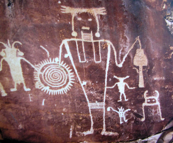
A volunteer at the visitor’s center had suggested that we watch carefully when passing through a narrow canyon containing a flowing creek and Cottonwood trees on both sides of the road. We would be rewarded with a view of features in the canyon wall that resembled a distorted human face that locals named “Picasso’s Face.” “You will need to watch carefully,” he said, “because it is easy to pass by without seeing it.” We saw it, took photos, and traveled further down the canyon where we observed Indian petroglyphs.

Finally, when we reached Echo Park and the Green River the very impressive, mile-long Steamboat Rock came into view. We hiked about a mile to the confluence of the Green and Yampa rivers and enjoyed the great views. Young rafters from Outward Bound floated by on the Green River after having negotiated through the deep Canyon of Ledore of the Douglas Mountains. Realizing that they had entered Echo Park, they started yelling and slapping their paddles on the surface of the water so they could hear the echoes. From my concealed location at the base of the canyon wall, I presented them with my best mimic of a wolf howl. The echo stuff stopped.
 |
| Rafters on Green River |
We ate our sandwiches under a welcoming shade tree in Echo Park. As we started back up the 17% climb, we noticed another dirt road heading east. Reading through our brochures, and studying our Utah Gazetteer, we found that this was the beginning of a 60-mile dirt and gravel road along the Yampa River. It passes along a bench between the river and the Blue Mountains and then heads up and over the Blue Mountains back to civilization. On a whim, we decided that there was still plenty of time left in the day to take this trip. Our brochure advertised several overlooks along the Yampa River that would produce exceptional vistas. We drove this long, slow, rocky, winding road, stopped and hiked out to every vista and saw much more majestic scenery. A few times, the 4-wheel drive kicked in to keep us from sticking in deep sand or to climb steep, rocky areas.
The views down into the Yampa Canyons were spectacular. The canyon walls were steep and rocky, the river below was lined with green cottonwood trees and the bench was covered with grass and Pinyon Pines. In the spring, when waters in the Yampa River are high, lots of folks raft this river. But, in August when waters are low, this river is virtually deserted.
 |
| Young Mule Deer Buck |
On the 36 miles of Yampa Bench Road, we saw no other cars and only about five humans who were swimming in the river. It was a very remote and quiet place – but it took a hard drive to get there.
We arrived back at Dinosaur before dark. We had seen lots of exciting wildlife, great views of the canyon land and a couple of river canyons. We saw no dinosaurs – live or dead – but we saw our first cougar. What a treat!
No comments:
Post a Comment